Explore Southwest Montana
Highways and byways of southwest Montana
Highways — some go where you have been and some go where you want to go next.
If you have traveled highway Montana 287 south out of Ennis you have been there. If you have never put wheels on that stretch of road it will take you where you want to go — through the heart of the Madison Valley and along the Madison River. It whispers distant visions of a place called Yellowstone. Sometimes it runs in a “straight as an arrow” fashion.
In the blink of an eye it becomes a concrete and asphalt serpent ascending and molding itself to the contours of the increasingly rugged mountain terrain. Meandering past mountain lakes, and beaver ponds, it pauses to reflect on emerging and spirited streams. It recalls an August night in 1959 when a mountain shivered with instant transformation.
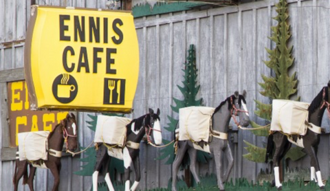
VISITING ENNIS MONTANA
Heading out main street Ennis toward the East you cross the Madison River. In immediate view, it is hard to miss the imposing yet serene view of Fan Mountain. It stands proudly in the Lee Metcalf Wilderness and peaks at over ten thousand feet above sea level.
Imagination conjures visions of the force, be it violent or quiet sculpting, that created such a magnificent structure of stone and earth. In the winter it takes on an entirely new aura. Snow gently finds its way into the fissures of the fan.
About two miles after the bridge that crosses the river the highway takes a gentle sweeping turn south.
Then, ten miles from Ennis is Varney Road. A sign that reads "Ennis National Fish Hatchery" marks the right turn that directs would be visitors. The fish hatchery stands seven miles west of US 287. The road is dirt and can be tricky in rain soaked or snow covered conditions. Mindful considerations of Mother Nature’s sudden whim’s with weather can prevent an other wise perfect trip from becoming a sudden nightmare.
Back on US 287 Cameron lies approximately two miles south of Varney Road. It is a small quaint settlement…mostly ranchers and farm folk. Many of the locals, as well as those who travel US 287, consider The Blue Moon Salon a must stop for food and liquid libations.
Continuing a southerly heading offers fleeting glimpses of the meandering Madison River off to the right.. On the left is Sphinx Mountain. With its summit of 10,876 it stands as guardian of the valley and entrance into the Lee Metcalf Wilderness. Rugged and challenging entry to the summit confronts those who ply dirt. rock and sparse vegetation to assail the peak.
Approximately twenty miles out of Ennis on 287 at Indian Creek is a right turn to the West looking toward the Gravelly Range. The road crosses the Madison at McAtee Bridge. Immediately after crossing the bridge there is a turn to the left. Once on the gravel road you begin another course South this time heading toward the Wall Creek Game Management Area. large rock formation overlooks the river and an incredible sweeping vista of the Madison Valley. A large elk herd numbering nearly two thousand animals spends winter here. This restricts access from early December thru the middle of May each year. It is prudent to check with local game officials before heading into the area during the late fall.
Returning to US 287 the road again lays a course South or to the right. The valley begins to narrow with the encroaching Madison Range to the left and the Gravelly Range to the right.
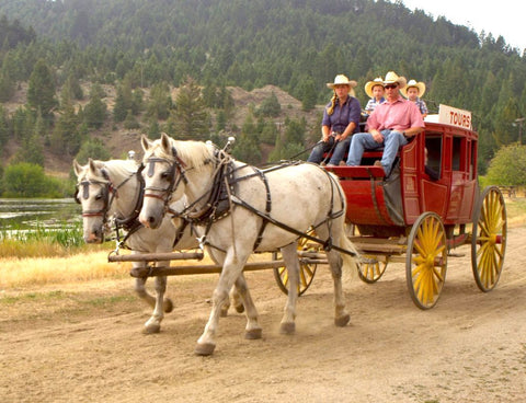
Photo courtesy of Virginia City Tours/Visit Southwest Montana
Thirty-four miles south of Ennis is the West Fork area of The Madison a turn off to the right leads down to camp grounds on the river and access to the National Forest. It is here that you will find the Hutchins Bridge. This is the location of the first bridge across the Madison. A celebration commemorating the centennial anniversary of the bridge occurred in the Summer of 2002.
You will also find on the near side of the bridge The Old Kirby Place. This a charming and well-restored and maintained cluster of historical structures. It was once a stop for the stage coaches venturing through the Madison Valley. A guest facility serving people who fish the river and tourists operates and maintains the facility. This is approximately the mid point of the journey to West Yellowstone, Montana.
From the West Fork area US 287 gently swings eastward. Approximately ten miles further South along US 287 a sign reading “Wildlife Viewing Area” marks a seasonal access to Cliff and Wade Lakes. It crosses the Madison River and climbs through sage brush meadows where deer and antelope are often in view with the naked eye. At the crest of the climb lie Cliff and Wade Lakes. They are a part of the Chain of Lakes that runs through this area.
Along the shores are seasonal accommodations, fishing access and hiking.
Heading East again, solemnly the highway climbs into the canyon region where the infamous and catastrophic earthquake occurred in August 1959. The convulsing earth shook shortly before midnight that fateful night.
MONTANA'S QUAKE LAKE
A cascade of dirt, stone and trees took the lives of the people and claimed the buildings they had built along the banks of the Madison. A first hand account from one resident in Ennis recalls the magnitude of the tremors that shook her out of her bed. The staff at the Visitor Information Center at Quake Lake offers detailed information about the quake. In the Winter it is advisable to contact the center for hours of operation and for schedules of guided hikes of the area.
A short distance farther along US 287 is the turn off into Camp Fire Campground. Approximately a hundred yards after taking the right turn into the entrance to the campground is a dirt road to the right. It parallels the Madison River through willows that are home to often seen moose. As with most of the roads in the region, seasonal conditions may limit access. Hiking, skis or snow shoes may be the modes of choice for those willing to challenge the elements for right of entry into this sacred domain.
No matter how challenging the access, the road offers a different perspective of the carnage of slide and rising water. Structures in various stages of decay lie across the river. The quake violently lifted these buildings off foundations and thrust them some three or four miles up river. Rescue teams carved openings in the "new dam” across the Madison. The structures of log, plank, and metal roof gently floated to rest amidst the sage bushes along the river’s edge.
From the sector of Quake Lake the road makes a steep incline. At the summit Hebgen Lake explodes into view with a burst of splendor. Hebgen is summer home to hundreds who migrate from other realms of existence. Winter brings acres of accessible frozen lake surface for those seeking a year round experience of mountain lake and forest shoreline.
Approximately nine to ten miles farther Interstate 20 intersects with Highway 80. A turn to the right diverts northwest and north to reconnect with US 287. A crossing of Reynolds Pass with its elevation of 6,836 feet above sea level returns the highway into the Madison Valley.
Some would venture that this is a long drive. Others say miles do not matter. Along this route there are miles like no other place on the planet. Rocks, trees, waters and animals seemingly reserved for this place imbue wonder and amazement.